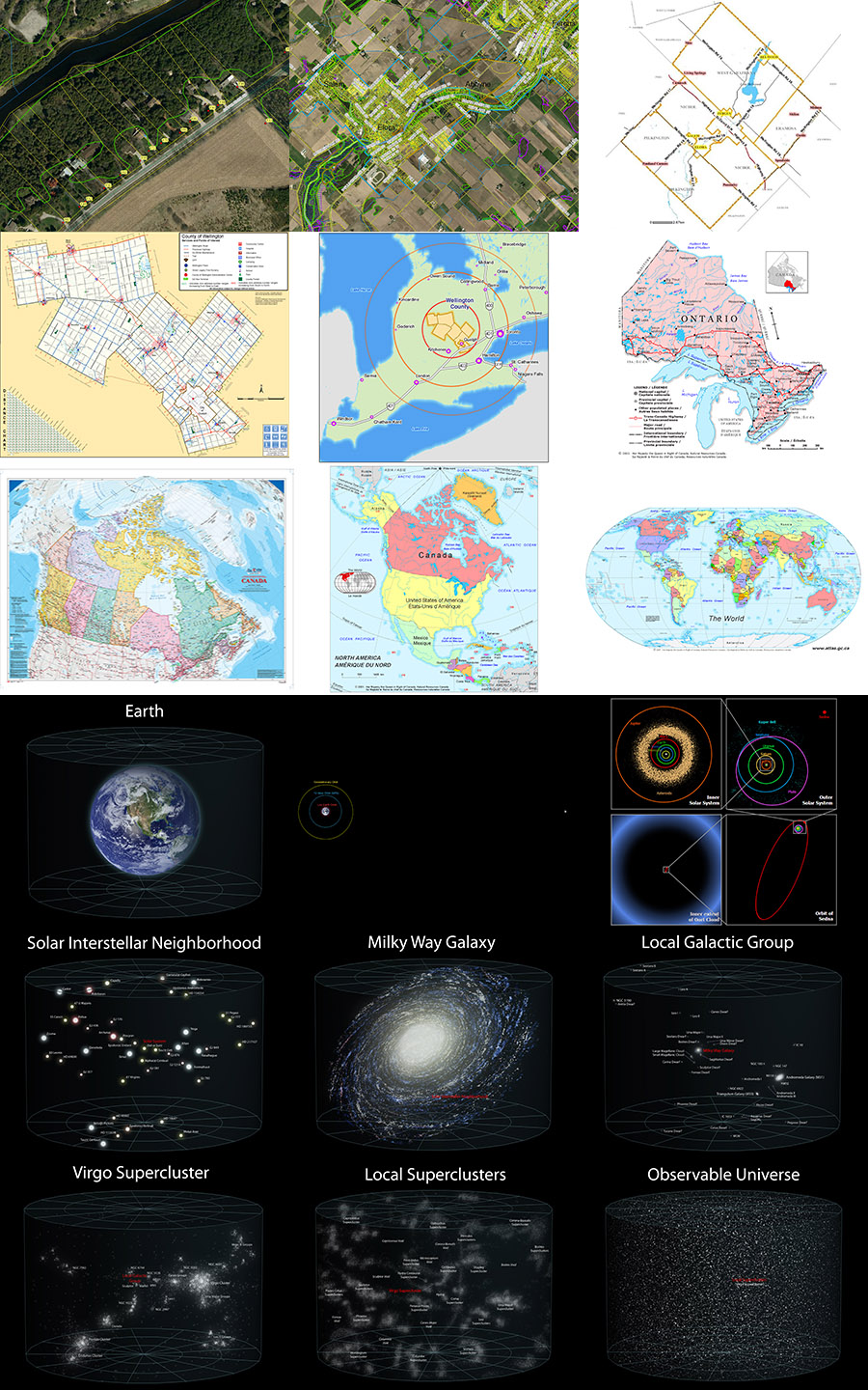
I've always had a thing for maps. One thing I've always wanted to do when I owned my own home is to pick a room and cover the walls with a series of maps, starting with the local neighbourhood and zooming out to the entire universe. This week I decided to follow through on my dream, but to scale it down a little bit so that all the maps fit in a binder instead of a whole room.
I collected a series of 18 maps from the internet, modifying some to suit my needs, and printed them out as 8x10 photos. Then I bought a pack of 20 photo album refill pages from Black's and put them in an old binder. I printed out a simple label for the binder that reads: "YOU ARE HERE". I also typed up a quick "table of contents" that gives a brief explanation for each of the 18 maps.
Here is an image of all 18 maps that I used for the project, starting at the top left with our property in Elora and zooming all the way out to the entire observable universe on the lower right. I tried to make it so that you could visually detect the scale differences at each stage, although it is difficult once you get out to the Galaxy level.
Technical Details: This is a composite of images downloaded from the internet and modified by me for my map project.
Can you post "click to view a higher-res version" like XKCD? Thanks!

And yes,
agree with all here... love of maps, zoom, etc... although the observable
universe (I believe) is now quite bit bigger than when that National Geographic
graphic was produced.
-- Aaron at 2:32am, Wednesday January 22, 2014 EST
I will see if I can post the full res image somewhere for you tonight.	I
didn't bother originally since the first 8 panels are pretty specific to my
little corner of the globe.  :)

Here is a link to the high res versions of 7
of the lower panels:

http://upload.wikimedia.org/wikipedia/commons/b/b6
/Earth%27s_Location_in_the_Universe_%28JPEG%29.jpg
-- Michael at 8:58am, Wednesday January 22, 2014 EST
Wow, that's high res.  I need a bigger monitor!

Other question I had was: what
are the lines in your first (and 2nd) image?  Contour lines?
-- Aaron at 4:46am, Thursday January 23, 2014 EST
Oh, I forgot to post the sources of the other images last night.  I got caught
up in another project that I'm working on.

The first two images were
screenshots from the Wellington County GIS Locator:

http://gis.wellington.ca/

The yellow
lines are property boundaries, and the green curve marks the boundary of the
Grand River Conservation Authority.  Since most of my property falls within the
GRCA boundaries, I need to get their permission if I am going to do any major
landscaping work or build any structures.
-- Michael at 8:51am, Thursday January 23, 2014 EST
Hosted by theorem.ca